All posts filed under: Outdoors + Adventure

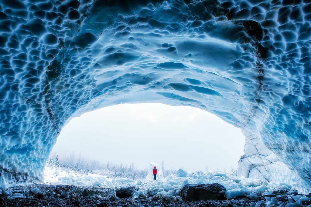
How Have I Never Heard of This Massive Washington Ice Cave Until Now?

I mean – hell – it’s literally a hop, skip and a jump over the border; basically on my doorstep and I had never heard of it until just last month. What are the Big Four Ice Caves? They’re naturally formed caves located on the north face of Big Four Mountain. Snow sloughs off the mountain in the colder months (aka an avalanche chute) and spring temperatures yield snow-melt streams which emerge from carved-out tunnels. Warm summer air further melts the ice but the shadow of the mountain prevents the caves from fully melting. So…just as soon as summer comes and the caves are accessible, let’s get in a car and go explore. Who’s with me? Images by the very talented photographer Michael Matti, via Flickr: CC BY-NC-ND 2.0 How to get to Washington’s Big Four Ice Caves From Vancouver, head south across the border and continue along I-5. Then, go east on Mountain Highway Loop via Granite Falls. Drive 34-km east of Granite Falls. The trailhead is just past Silverton. At just 2.2 miles, the trail to …

The Snowshoe Grind Isn’t the Hell-Hath-Frozen-Over Workout It Sounds Like

I had seen the Snowshoe Grind advertised on Grouse Mountain’s website. My immediate reaction was, “As if hiking the Grouse Grind isn’t torture enough.” Now, factor in the awkwardness of snowshoes. Sounds. Awful. Well, I’m here to debunk the Snowshoe Grind myth because my gal pal and I unintentionally did the damn thing last Saturday. And I was wrong. It isn’t the hell-hath-frozen-over workout it sounds like. It was awesome and it made me so grateful to live in Vancouver. First, the Snowshoe Grind is completely independent of the Grouse Grind. The trailhead starts atop the gondola, near the ice rink. Second, where the Grouse Grind is a 2.9 km, one-way trail, the Snowshoe Grind is 4.3 kilometres out-and-back. It starts as a groomed path, which keeps up for maybe a quarter of the way. Walking this bit, you’ll wonder whether you should have bothered with snowshoes at all. Soon enough, the trail narrows and leads grinders uphill through a pretty forest. Snow falls from overburdened tree boughs. The sunshine illuminates the diamond dust that blankets …

Hiking Treasure Loop Trail in Lost Dutchman State Park (PHOTOS)

Greg and I were in Scottsdale and Mesa (Arizona) earlier this month and I couldn’t leave town without squeezing in some hiking at Lost Dutchman State Park. Why? The Superstition Mountains; I mean…they’re iconic to the Mesa-area. Treasure Loop Trail: 2.3 miles (3.8 km) Rating: Easy Elevation gain: 500-ft + then – 500-ft Location: Lost Dutchman State Park Trail notes: A well-maintained trail that winds through the low scrub of Tonto National Forest. This hike is not demanding for those who are physically fit. If you’re after a workout, opt for Siphon Draw Trail which involves some scrambling. “Standing in a parking lot at the ominously named Lost Dutchman State Park, I’m far from winter’s reach. But will Arizona’s heat will dry my running nose? I stuff a litre of water into my backpack and think what a cruel irony it is to suffer a cold in the desert.” Continue reading about our hike here: http://www.explore-mag.com/Go-Here-Hiking-Below-the-Superstition-Mountains-in-Lost-Dutchman-State-Park-PHOTOS  Otherwise, enjoy the photos! Have you hiked beneath the mighty Superstition Mountains? Let me know: comment below!  

We Are the Crazy Canadians Who Honeymooned in Bolivia

Text originally published in Canadian Traveller magazine, Fall 2016 Excuse Me While I Kiss the Sky Few places provide such an unworldly sense of advneture as Bolivia. From the mesmerizing way the earth meets the sky at Salar de Uyuni, to the star-splattered desert night skies that will simply play with your mind – to say a trip to Bolivia is ‘epic’ could perhaps be something of an understatement.   Bolivia has few qualities of a destination that attracts honeymooners. It’s landlocked, mountainous, high altitude, and in February it happens to be pretty damn wet. But no one can convince me to go elsewhere. Tucked deep in the South American continent, few travellers arrive in Bolivia by chance. I’m reminded of this each time I’m queried, “What brings you to Bolivia” not by locals, but from other travellers. It’s as if we are all ‘in’ on the secret but want to know who – or what – gave it away. My husband and I have come to Bolivia to lose ourselves in Salar de Uyuni’s …

5 Trails You Definitely Need to Hike in Zion National Park

Spending one short day in Zion National Park was an absolute tease; I’m already keen to return. I dream of spending a whole week camped out in the canyon, waking each day to wade the Virgin River, scramble precarious ridges and catch golden sunsets. Here are four trails I’m raring to hike and one I’ve already completed. Happy trails x 1. The Narrows – Bottom Up Length: As far as you want to go; up to 8 km (5 miles) one-way. This is an out-and-back trail. How hard is it? Easy – as long as you don’t roll an ankle and don’t mind cold water. Elevation gained/lost: Negligible, mostly flat. How long will it take? Up to 4.5 hours one way. Again, it depends how far you go. Where is the Bottom Up trailhead? Stop 9 – Temple of Sinawava. Follow the paved Riverside Walk one mile to the end. If you are taking the Zion Canyon Shuttle, you should budget 30-60 minutes from park entrance to the trailhead. Equipment: Wear footwear you’re okay fully submerging underwater …

Roadtrippin’ America: Day II Zion National Park

Hailing from British Columbia, I’ll admit, I thought I lived in the most beautiful place in the world. That was before I visited southern Utah. Tuesday, October 11 Waking up in Mesquite, Jason and I packed up the truck, crossed into the northwestern tip of Arizona and then pushed onward into Utah. Immediately the land became cragged and dramatic. Grey skies overhead threatened rain but by mid-morning the dullness of the day had burned off. We grabbed coffee in St. George and then followed I-15 north until exiting at Hurricane. From here we drove east along the Virgin River toward Springdale. On the advice of my contact at Visit Utah, Jason and I had settled on hiking The Narrows. The trail isn’t so much a trail, but a shallow river that leads hikers through an increasingly narrow gorge. The Narrows and Angel’s Landing are counted among Zion National Park’s most popular day hikes. In Springdale, we popped into the visitor centre where I picked up an inexpensive but adequate pair of water shoes and a collapsible walking …

Hiking to Eagle Bluffs Viewpoint in Cypress Provincial Park, B.C.

Location: Cypress Provincial Park Park here: 6000 Cypress Bowl Road, Vancouver Hike Distance: 8-9 kilometres (round-trip) Hike Duration: 3-4 hours (10:30 start/2:30 finish, 20-30 minutes at Eagle Bluffs) Difficulty: Intermediate What makes it intermediate? A 1.8-km uphill start Park website: env.gov.bc.ca/bcparks/cypress Eagle Bluffs has become a very popular hike because the viewpoint offers unobstructed views of Vancouver, Georgia Straight, West Vancouver, Howe Sound, Bowen Island and Gibsons. I’ve been meaning to hike Eagle Bluffs for some time now, but when I first attempted it April 30th the trail was still too snowed-in for my runners. I ditched and headed for Dog Mountain in Mount Seymour Provincial Park. Today of course, was a bright, bluebird August day. Only thing was, I didn’t have anyone to go with. Then I thought about the hundreds (thousands?) of people who would be hiking to Eagle Bluffs. So off I went. Finding the Trailhead After exiting Highway 1 to Cypress Provincial Park, drive until the road ends at Cypress Ski Area. Along the way you’ll surely see cyclists making the long slog to …

How I Nearly Killed Greg’s Dream

Okay, a motorbike trip to Pai, sure to be a highlight of the trip. One obstacle: I have never driven a motorbike. Pai is a darling little town in the highlands, approximately 130 kilometers north of Chiang Mai. The journey begins with 30km on a Thai expressway and the 98km after the exit is characterized by 794 curves and a steep ascent through the mountains. The trip can be done in 3-5 hours from Chiang Mai.    One night in a pub, Greg heard that many make the trip to Pai by motorbike and he was instantly sold on the idea. Okay, a motorbike trip to Pai, sure to be a highlight of the trip. One obstacle: I have never driven a motorbike. But I can learn right?    Let me take a moment to digress. Greg and I have very different learning styles. While on Ko Tao, Greg had been griping about the amount of scuba diving theory and lecture we had to do before getting into the ocean. With Jason and I as …